 With rising temperatures and scarce potable water, Delhi must address the the under-researched and yet widely experienced phenomenon of climate change at the urban scale in its next master plan, writes Mahak Agrawal.
It is important to highlight the under-researched yet widely experienced phenomenon of climate change at urban scale, especially in light of latest developments with respect to planning exercise of Delhi (as notified in The Indian Express on July 24, 2017 titled DDA and urban affairs institute team up for a master plan for 2041- http://indianexpress.com/article/cities/delhi/dda-and-urban-affairs-institute-team-up-for-a-master-plan-for-2041-4764149/). The intent of the article is to highlight the severity and urban manifestations of climate change for the capital city, whose trends and policies often form a blueprint for replication for others.
The National Capital Territory of Delhi, after six decades of urban planning fails to address multifaceted issues of climate change in its plan documents and practice. The capital city expanding, spatially and numerically beyond its carrying capacity of 13.5 million is dying a little every day. As recent data has revealed, Delhi’s surface temperature is increasing 1.5 times the rise in air temperature, aggravated by depletion of vegetative and water-based heat sinks. The city is bound to get hotter by 3°C (surface temperature) in the next 20 years in the business as usual scenario, calling for serious rethinking and radical climate resilient measures on part of citizens, planners and implementing organisations alike. A city is more than just a place in time, after all.
Delhi, like several other urban centres of the Indian subcontinent, has witnessed the rise and fall of several empires and governments. British India announced Delhi as its administrative capital in 1911, but it was not the Britons who initiated urbanisation or for that matter urban development of the city. Prior to the former, Delhi had been if not the capital, a prime location for several empires, establishing their urban administrative centre of Indraprastha, Siri, Tughlaqabad, Jahanpanah, Firozabad, city around Purana Qila and Shahjahanabad, with the last one being New Delhi- administrative and political centre of British India until India attained its Independence.
While some of these urban centres came near the water spine of Delhi, which is the river Yamuna, many others utilised its terrain of Aravalli ranges for water harvesting and defence. The common feature for all these eight cities of Delhi was their utilisation of the city’s natural features and resources while planning, developing and sustaining a city life for their emperor and pupils alike. Seven decades later, the city is choking in its own waste and emissions, while at the same time adding more than a million population from villages or smaller urban centres. What is it that makes Delhi an attraction for these millions, despite its depleting environment and public health status? Where/why/how did we go wrong?
The answer is not simple or straightforward. The city for its location, natural resources and features, has seen many developments and events. It continues to remain the administrative seat of governance for India and more often than not, forms a blueprint for replication for others. For example, Delhi was the first city in India which has a comprehensive master plan formulated for its development post-Independence. To date, several urban development authorities refer to the first master plan of Delhi (1962) for reference and guidance while formulating their own documents. Delhi metro, one of the most successful mass rapid transit systems in the country, is looked upon by various other cities while designing and conceptualising their own transit systems. Being the capital, several central schemes in the past have chosen Delhi as a mission project for a development, rejuvenation or policy implementation- learnings from which are utilised for other cities and towns later.
Post-Independence, the capital city became a centre of decision-making and a harbinger for millions of people seeking refuge amidst partition. 1950s was a dichotomous era- while planners, architects and engineers were busy drafting a workable master plan document for the city, its land development and civic authorities were under stress of finding land and basic resources for the refugees. Several pockets of rehabilitation colonies came up around Lutyen’s Delhi. By the time, the first plan was notified and put into implementation, the country was closing to a decade of political and economic turmoil. In early 1990s, when political stability was established, the country opened its economy and shifted its emphasis on urban centres for future developments, particularly economic developments. Between 1985 and 1995, drastic changes were noted in urban development pattern. For Delhi, the changes were significant (as indicated in Table 1). The City’s build up escalated at the expanse of water bodies and agricultural land. By the time the second master plan was notified, the city has undergone another wave of tremendous construction during the Asian games, and was now home to makeshift shanties of migrant workers that flocked to the city from villages.

Extracted by Author (2017) from USGS (1986, 1996, 2006 & 2016)
Continued emphasis on the city, nationally and globally, projected Delhi as the centre of employment opportunities and as a result, by the late 1990s, Delhi was one of the most populated and polluted urban centre of India and the world. But the city continued to expand, primarily with increasing speculations, and between 2006 and 2016, city depleted its resources to the extent that it has now crossed its carrying capacity, that is the maximum population it can sustain based on a city’s resource base of potable water, agricultural production, etc. At present, the capital depends on surrounding states and non-neighbouring hilly regions of the north for its basic requirements of drinking water. Its own water resources are either insufficient or filled with sewage or polluted beyond potable and every decade, the city’s green belt and water bodies are disappearing under concrete, while the temperature- annual average and surface temperature (as illustrated in Figure 1, below), are soaring.
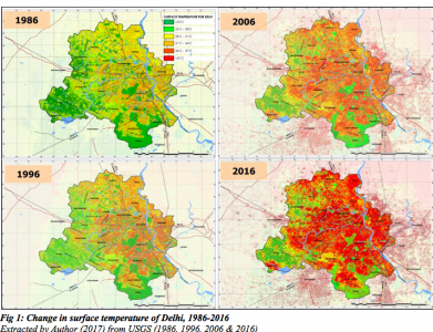
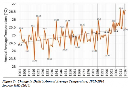
The city’s annual average temperature has risen by 1.05 0C in the past 100 years (Figure 2, below), with 0.20C gain since 1986. But the surface temperature, which is most affected by microclimate of the region, has soared by 30C since 1986. And the latter is just an average figure, the real increase varies spatially across the city, with core areas witnessing a rise of as high as 40C.
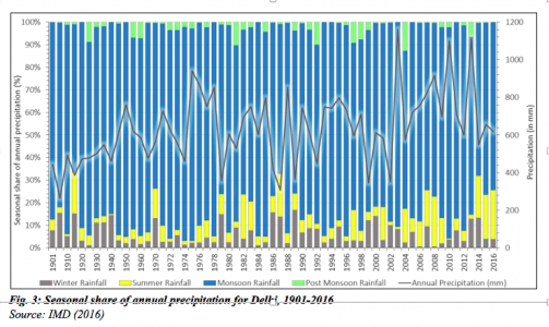
Spatio-temporal and empirical analysis using geospatial modelling tools and raw data from Bhuvan India, GLCF, USGS in support of statistical data gathered from several government departments, support the changing climate of Delhi, its variability and its relation to urban development and destruction. Rainfall patterns are changing- summers are getting wetter (Figure 3, below), while the monsoons are becoming intense. Each year, almost half of the city becomes choked during monsoons amidst the blame game of who is responsible for cleaning and unclogging of drains. What no one seems to question however, is who is to blame for this mayhem?
One cannot blame the government for everything. Or a development authority which, in its last master plan in 2007 – a time when climate change discourse was at the centre of global discourse – failed to mention climate change or variability, and for that matter even the climate profile of the city.
We are the ones who want air conditioning to beat the heat, or chop down tress to build new home, and pave over drains to reduce travel time. Pointing fingers is easier than realising one’s own contribution to this vicious cycle of urban development-environment- climate variability and their consequent effects.
Little more than three years remain before we brace ourselves for the new master plan document, or rather a strategic plan document – it thus, becomes imperative that we rethink our approach towards urban development and understand where we went wrong, to witness a city that is not choking or wilting under stress.
This article gives the views of the authors, and not the position of the South Asia @ LSE blog, nor of the London School of Economics. Please read our comments policy before posting.
Cover image: A smoggy view of Delhi. Image credit: M Field, Wikimedia Commons, CC BY-SA 3.0.
About the Author
Mahak Agrawal holds a Masters and Bachelor’s degree in Urban Planning and Physical Planning from the School of Planning and Architecture, New Delhi. She currently works as an independent research analyst and climate consultant. She also volunteers with the ISOCARP (International Society of City and Regional Planners).

