 Poor air quality is still a major issue affecting a large number of Americans. In new research, Nikhil Kaza and Josh McCarty write that how urban areas are laid out can make a difference to local air quality. Using remote sensing data for continental United States, they find that both sprawling cities and mixed urban and rural counties are more associated with poor air quality. The more fragmented communities are, the worse the local air quality. They argue that increasing the amount of forest cover near to these areas will help to improve air quality.
More than 40 percent of Americans live in parts of the country where air pollution levels are dangerously high. But what determines where is the most affected by air pollution? A location’s air quality depends on a number of factors including pollutant sources, meteorology and landscape features such as basins. Different pollutants have different spatial spillovers and have differential effects on human health. Thus it is useful to understand the impact of various factors in air quality. The configuration and composition of urban area is an important determinant of air quality. In recent research, we demonstrate how patterns such as leapfrog development and the mixing of urban and forest land uses have an impact on air quality.
We expect the urban form to influence air quality in a number of ways. A sprawling urban spatial structure is associated with larger amount of travel, especially by car, which in turn has an effect on particulate matter emissions and pre cursors compounds to Ozone. Building configurations and tree cover in an urban area in turn influence atmospheric chemistry and affect local pollutant levels. Impervious cover impacts Ozone formation. However, very few studies have established the relationship between urban form and air quality for different levels of urbanisation.
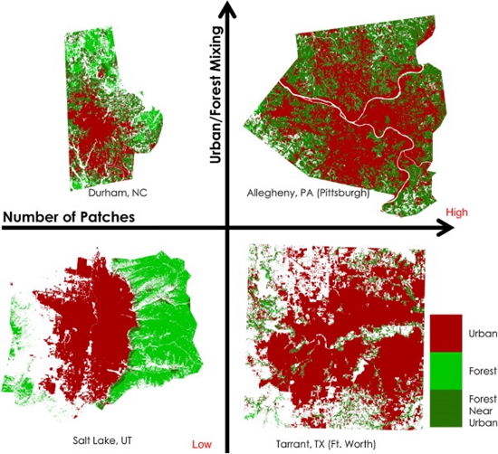
To remedy this, we use widely available land cover data to characterise the urban form in every county in the conterminous United States. The land cover data is derived from remote sensing and characterises every quarter acre of land in the continental United States into one of 20 classes including 4 urban classes. This represents about 9 billion observations and we calculate urban form metrics from contiguous urban land within a county for almost 3000 counties. These urban form metrics are metrics of configuration (such as urban-forest mixing index, eccentricity) and composition (such as amount of urban land, forest cover) (see Figure 1).
Figure 1 – Examples of different types of urban patterns in the U.S.
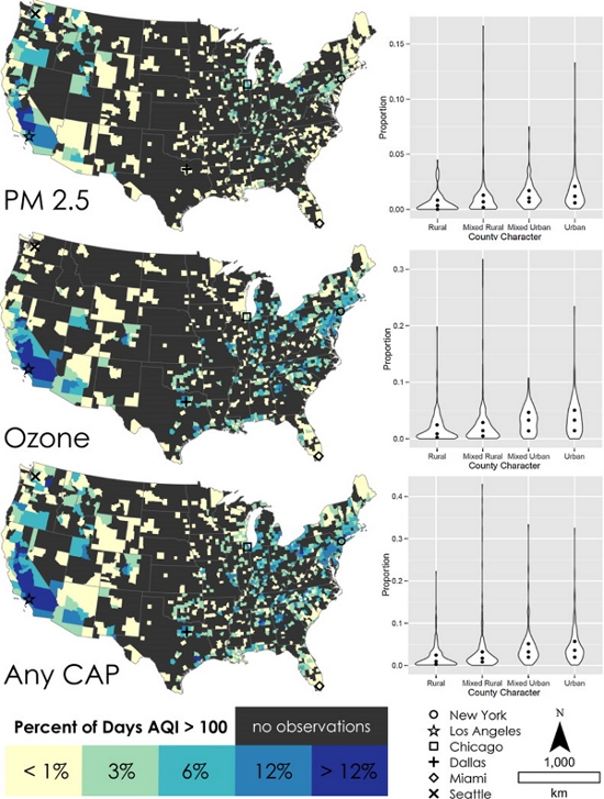
We relate these urban form metrics to data on air quality in a county. The Environmental Protection Agency (EPA) continuously collects air quality data from approximately 1300 monitoring stations across the United States stations measuring different Criteria Air Pollutants (CAP) such as Particulate Matter (PM 2.5) and Ozone (O3). EPA then assigns an Air Quality Index (AQI) based on National Ambient Air Quality Standards (NAAQS). AQI runs from 0 to 500, with the value 100 deemed the acceptable standard from a public health perspective. We use the proportion of days with AQI above 100 as an indicator of bad air quality in a county.
There is a spatially variegated pattern of bad air quality in the United States. Most of the AQI exceedance days for Ozone are in California, the Northeastern corridor and the South. PM is particularly problematic in the deserts and forested areas of the US. In general, urban counties have bad air quality, which is not surprising. What is interesting is that mixed urban and mixed rural counties also have similar distribution of the number of days whose AQI exceeds the recommended levels (see Figure 2).
Figure 2 – Distribution of low air quality days
By controlling for both spatial spillover effects and effects of other factors such as population and size of the county, we find that fragmentary urban patterns which are characterised by a high number of urban patches, as shown in Figure 1 above, are positively associated with an increase in the number of days where the AQI is above 100. The result is statistically significant for all types of pollutants considered. In contrast, an increase in the amount of the nearby forest reduces the number of low air quality days. However, forests are not always salubrious. Increasing total forest area in a county is correlated with more Ozone exceedance days.
This suggests that while fragmentary urban form is undesirable from an air quality perspective, it is much more undesirable in areas without forest cover for many pollutants. As agricultural land is easier to convert into urban land, many greenfield developments are in agricultural zones at the fringes of existing urban areas. If a fragmentary pattern of urban development must be pursued, preserving forested areas would help mitigate the effects of some pollutants.
Our analysis focused on air quality as measured by the AQI. From a public health perspective, however, exposure may be more important than the air quality. Therefore, it is necessary to extend these kinds of studies to include differential exposure and risk to different groups. Local air quality at a street and neighborhood scale is dependent on urban form at a street level and determines urban canyons, local vegetation characteristics and surface temperature. Exposure studies should focus on micro level design interventions that may help mitigate pollutant impacts to high-risk groups.
Nevertheless, we find that after controlling for demographic factors and the level of urbanization, both the pattern of urbanization and the mixing of different land cover types are important correlates of pollutant levels and air quality. Public action for mitigating pollutant levels could refer to land use strategies in addition to other emission control mechanisms.
This article is based on the paper “Urban Form and Air Quality in the United States” in Landscape and Urban Planning.
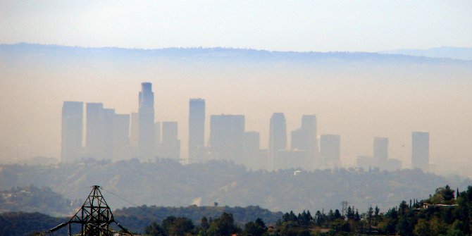
Featured image credit: Bob Travis (Flickr. CC-BY-NC-2.0)
Please read our comments policy before commenting.
Note: This article gives the views of the author, and not the position of USApp– American Politics and Policy, nor of the London School of Economics.
Shortened URL for this post: http://bit.ly/1B4YxOZ
_________________________________
Nikhil Kaza – University of North Carolina at Chapel Hill
Nikhil Kaza is an Associate Professor in the Department of City and Regional Planning at the University of North Carolina at Chapel Hill. He studies the phenomena of plans and their uses in public and private decision-making. Of particular interest are urban development processes, energy planning and land use impacts. His research seeks to analyse the motivations and plans of multiple intentional actors endowed with limited capabilities, imperfect foresight and distributed authority in urban settings.
Josh McCarty – Urban3
Josh McCarty is Urban3’s Chief Analytics Researcher and resident Geo-Accountant. Geo-Accounting, a portmanteau of geography and accounting, is inspired by the foundational geodesign work of those such as Ian McHarg. Just as geodesign seeks to improve design through spatial awareness, Josh’s work focuses on new ways to visualize local finance. His work focuses on the relationship between patterns of development and economics.