by Lizao Chen
A systems approach offers an integrative perspective to understanding how cities evolve. Decision makers need to develop a balanced, multimodal transportation system that responds to city and car collisions, namely increasing traffic congestion.
The article applies a systems approach and managerial strategy to address this, drawing on examples from the UAE. Indeed, transportation systems (such as highways) and mobility services (ridesharing) are essential to providing access to diverse socioeconomic activities. While they heavily invest in highway and toll roads, cities are also investing in metro systems and electric buses. What exactly are decision-makers trying to achieve? Cities built around cars would look and operate drastically different from those built around pedestrian-centric public transport. This piece focuses on the relationship between public transport and car use, and the corresponding measures necessary to create liveable cities.
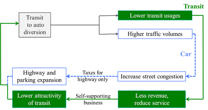
Cities around the world are undergoing a series of transitions. The essential challenge to their growth is the ‘vicious circle’ illustrated in Figure 1. Indeed, many city planners do not have a full understanding of the forces behind increases in traffic congestion, decreases in transit use, and the deteriorating conditions affecting pedestrians and the environment. This dynamic in turn makes such places less liveable and green. Cities make short-term improvements to their transportation systems by building more roads and parking facilities, but in the long-term, the problems are more serious than these improvements can address. For instance, in Texas, Governor Perry spent $2.8 billions of taxpayers’ money to widen the Katy freeway (the interstate highway no. 10) from 8 lanes to 26 (12 main ones, 8 feeders, and 6 high occupancy vehicle lanes). Aside the massive landmass taken, the total travel time on average increased 30% more year-over-year (YOY) after the expansion’s completion.
A systems approach to this situation is used here to explain this fundamental urban transportation problem and the policies that address it. Figure 2 shows car travel time on streets or highways for a given distance, as the traffic volume (cars per hour) increases. The speed is constant when the traffic volume is low. As the number of cars increase, traffic speed decreases, causing travel time and costs to increase, which leads to congestion, halted vehicles, and theoretically infinite travel time. The total disutility of travel (in other words, a negative spillover effect), including the lack of comfort and safety, operating costs (amongst other factors), increases with travel time. With regards to transit systems, there is an inverse relationship between the number of passengers and their travel time. As shown in Figure 2 again, when passenger volume q (trip/hr) is low (for example, when the service is a bus every 30 minutes), the cost per person is very high. As the passenger volume increases, service frequency increases. As a result, more investment is put into the rail system, in order to build higher service quality -including the speed, reliability, and cost of travel.
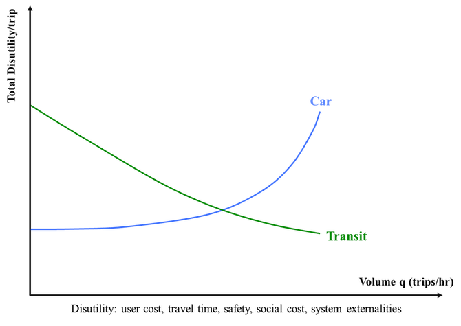
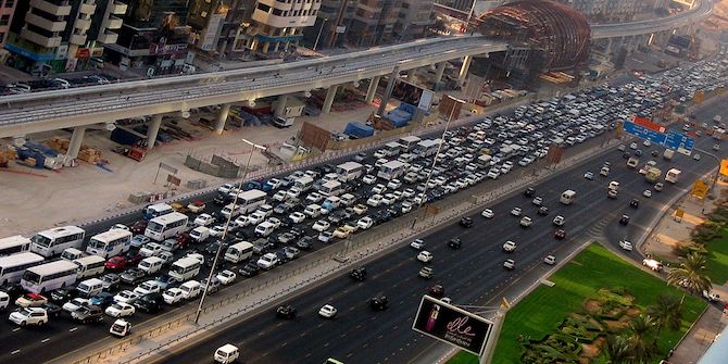
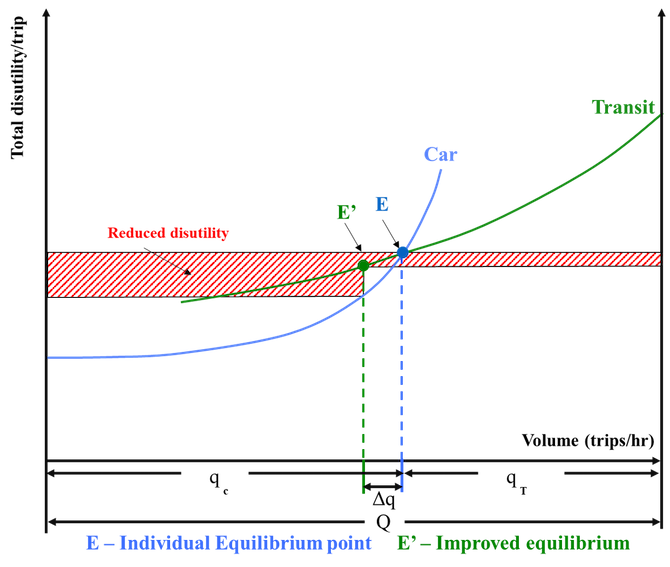
Figure 3 shows the distribution of Q passengers travelling in a joint corridor by car (from the left) and by transit (from the right). For example, the photo above shows a highway parallel to a metro line on Emirates road, which lies between the cities of Dubai and Sharjah. As passengers mostly select the lower disutility mode, their distribution between car and transit will be at the equilibrium point E: qc passengers use cars, while qT passengers use transit. If one could shift Δq persons per hour from cars to the transit line, the latter’s service would be improved through greater train frequency, and congestion on the highway would decrease. Thus, travellers on both transit and highway would benefit; shifting travellers from cars to transit leads to a system optimum; minimum total disutility on both modes. However, as Figure 3 shows, in the situation after the shift of Δq persons, shown as point E’, the disutility of individual travellers would be lower on the highway than on the transit, such that if individual travellers would decide by themselves, the Δq of them would return to the highway, or to the original equilibrium point E. Therefore, the optimal condition based off individual travellers’ decisions is not optimal for the entire system.
As such, cities with more balanced transportation conditions for liveable environments are ones in which decision makers understand the aforementioned relationship and apply two sets of policies to shift a substantial portion of car trips to transit ones (i.e., moving from assessing individual travellers’ choices to considering the system’s optimal condition – whereby the total disutility on both modes of travel is at its minimum). To achieve such an improvement, cities have consistently applied two sets of transportation policy: incentives to use transit and disincentivising car use.
Figure 4 shows how these two sets of measures result in a shift of the equilibrium point from the individual equilibrium point (IE) toward the system optimum (SO): transit incentives move the T curve down to T’, whereas auto disincentives move the C curve up to C’. The result is a shift of travel from car to transit such that the distribution between them, known as MODAL SPLIT, goes from the initial IE toward the SO through the individual decisions of travellers, and remains stable there. Figure 4 demonstrates how the total disutility of travel on both modes, which was initially at the IE level, has been reduced to SO, again equal on both cars and the transit system.
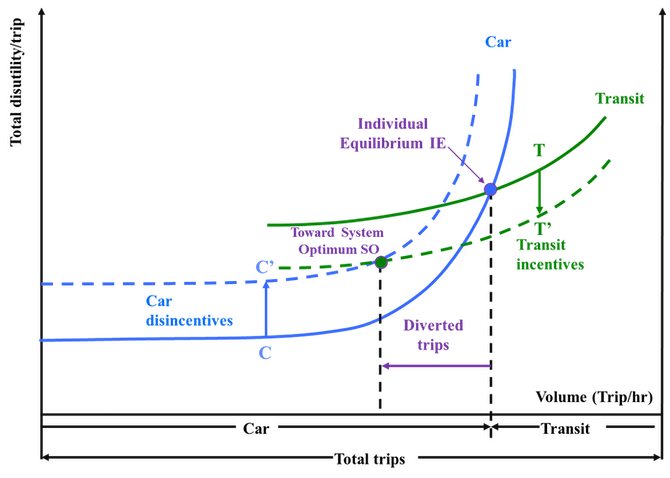
Transportation system operations based on IE are much less efficient and cause more serious negative impacts than their operations at SO travel distribution. Cities which attempt to solve their traffic problems by building more streets, highways, and parking facilities are going into transportation condition based on IE. To be liveable and greener, cities must consistently implement the following: incentives to using the transit system, a pedestrian-friendly urban environment, as well as policies that discourage car use.
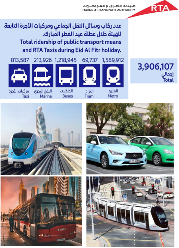
The Dubai Road and Transport Authority illustrates this (see photo below). Transit and walking incentives consist of a variety of measures (such as building new transit systems, and providing more frequent, reliable, and faster services). These improvements may be physical, operational, financial, and may be short-term measures or long-term policies. Many physical measures attempt to disincentivise car use, such as introducing pedestrian streets, zones or squares, meter parking, road pricing, gasoline taxes, limiting parking supply, and so on. The policy to disincentivise car use does not mean that there should not be any street or highway improvements. Rather, it means that traffic congestion should be tackled by discouraging car use, as too much street and parking expansion makes cities less green and liveable.
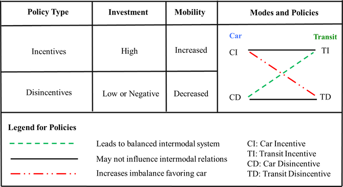
A comprehensive oversight of the car and transit incentive and disincentives policies (CI, TI, CD and TD, respectively), investment decisions, and their mutual relationships are given in Table 1. Combinations of CI – TI and CD – TD result in increased and decreased mobility, respectively, but they do not change the modal split. For instance, building a parallel freeway and metro line represents an investment in competing facilities without improving liveability and mutually jeopardising each return. The CI – TD, which is still being adopted in many cities’ investment decision, makes a city more car-dependent and less people-friendly. The CD – TI combination is the optimal combination for a greener city and is proven to strengthen national long-term competitiveness along with sustainable city growth.
This piece is part of a series on urban development and the role of road infrastructure in forging socio-spatial conditions, based on contributions from participants in a closed LSE Roundtable in September 2021. Read the introduction here, and see other pieces below.
In this series:
- (Re)thinking Streets in Low Urban Densities by Alexandra Gomes, Apostolos Kyriazis, Clémence Montagne & Peter Schwinger
- The Future Development of the City of Kuwait: Kuwait’s Urban Form as a Case Study by Roberto Fabbri
- Pedestrian Dynamism Index: An Approach to Increasing Permeability between the Peripheral and Central City of Guadalajara by Monica Castañeda, Ricardo Fernandez and Roberto Robles-Arana
- Studying Abroad in Stockholm: Incentivising Young Adults Towards Greener Mobility by Ningning Xie
- Plan with a Purpose: A Systems Approach in Transportation Development and Liveable Cities by Lizao Chen
- Metropolisation and Spatial Segregation in Gulf Cities: The Cases of Abu Dhabi and Dubai by Moiz Uddin
- Rethinking Streets in North Obhur, Jeddah, Kingdom of Saudi Arabia by Alok Tiwari
- Safe and Active Mobility: A Prototype for the Re-Pedestrianisation of Residential Neighbourhoods in Oman by Gustavo de Siqueira
- Urbanisation and Physical Activity: Addressing the Needs of Omani Women by Ruth Mabry and Huda Al Siyabi


Livable cities? They are like a cancer, consuming resources from everywhere else to prop them up. Humanity really needs to stop the current development trend of concrete everywhere, it’s destroying ecologies all over the place for human convenience. Eventually it’ll catch up to the humans and it might be too late.