
 Gentrification and access to the city is a key issue in many urban centers today. Annelise Grube-Cavers and Zachary Patterson examine the relationship between gentrification and access to mass transit in Toronto, Montreal, and Vancouver. They find that exposure to a transit station is related to gentrification in Toronto and Montreal, but not in Vancouver. They call for more research on this subject, so that planners can establish and incorporate transit in a way that would allow the residents who would most greatly benefit from proximity to public transportation (low-income, working class households) have sustained access to it.
This article was originally published on the LSE’s USAPP blog.
Gentrification has been receiving a lot of coverage in the news in the past few years, and the academic world has been equally curious about the phenomenon. Gentrification is typically characterized as an influx of middle and upper-class households moving into previously working class neighborhoods. It results from a variety of causes, including the construction of transit infrastructure.
As an important public investment in cities across Canada and the world, transit has a range of effects on the city around it, not all of which are properly understood. Property value and the cost of housing are both affected by proximity to transit and are also important indicators of gentrification. As early as 1983hedonic price models were being used to demonstrate that proximity to Toronto’s subway system increased surrounding property values.
Increases in land value, however, represent only one aspect of gentrification and despite the large amount written on the topic of transit and land-value, there is a dearth of research when it comes to gentrification and transit with only a few studies released and none conducted in Canada.
The process of gentrification can have significant and adverse effects on existing residents of neighborhoods including the displacement of existing residents. Though this is a point of some contention, the displacement of lower-income families from inner-city neighborhoods is a factual and visible change occurring. A study of Toronto shows the predicted patterns of wealth over the next three decades and it does not bode well for low-income households’ access to the city center and, consequently, to the best-served transit areas.
In the three largest Canadian cities; Montreal, Toronto and Vancouver data from over 50 years was analyzed to establish whether there is a connection between the implementation of transit stations and gentrification in surrounding neighborhoods. This was done using census data, first establishing which neighborhoods were gentrifiable and then looking at changes in key indicators including income, monthly rent, education levels, occupations and proportion of owner-occupied dwellings. A gentrifiable neighborhood is one that is dominantly working class, with a lower than average income and education levels. Changes in indicators between census years (e.g. between 1961 and 1971) were then compared with the changes over the same period for the relevant census metropolitan area (CMA).
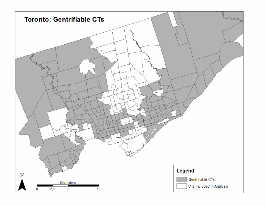
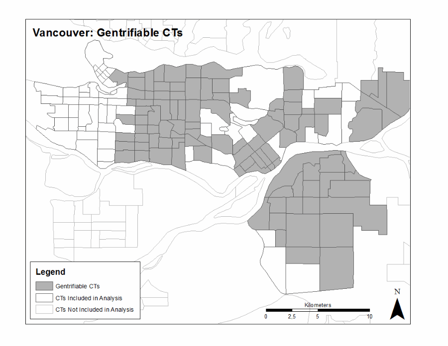
The results are striking in the cities of Montreal (Figure 1) and Toronto (Figure 2), where a visible expansion of gentrification emerges, spreading slowly from both the transit networks and the central business district. In Vancouver the gentrification that occurred after 1981 (the start of the study period the census prior to the opening of the skytrain in 1986) is sparser and shows less of an obvious spatial pattern (see Figure 3).
Figure 1: Gentrification Expansion in Montreal
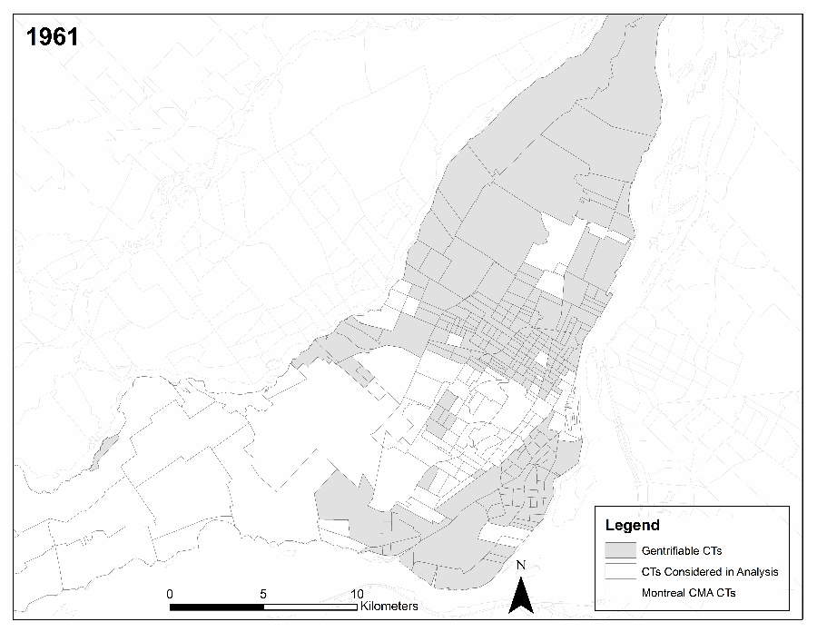
Source: http://usj.sagepub.com/content/early/2014/03/17/0042098014524287/suppl/DC1
The statistical significance of the effect of proximity to transit on gentrification was tested using Survival Analysis, a statistical approach most commonly used in bio-statistics to estimate phenomena like the effect of smoking on the likelihood of getting cancer (see Kleinbaum and Klein Survival Analysis: A Self-Learning Text for a good introduction to this type of analysis). The model showed that while controlling for various other variables, exposure to a transit station had a statistically significant effect on gentrification. In Toronto the model demonstrated that a census tract located 550 meters away from a transit station was 5 times more likely to undergo gentrification than a census tract located further away from the network. Similar results were found for Montreal.
Figure 2: Gentrification Expansion in Toronto
The analysis of Vancouver told a different story, revealing that gentrification in that city is not related to a neighborhood’s proximity to transit. In 2012 a study released showed that unlike in other cities, income was decreasing around transit stations.
Figure 3: Gentrification Expansion in Vancouver
Gentrification is more likely to occur around transit in Montreal and Toronto, though this is not uniformly true for all stations. The findings corroborate recent results looking at the effects of proximity to transit on land and property-value and the relatively recent emergence of transit oriented development as an important design form. The topic needs to be further investigated, and would benefit from a more in-depth analysis of the effects of policy on gentrification, specifically housing policies that are implemented near transit or at the same time as transit is being planned or built.
Gentrification is of concern because of the rapid transformation that occurs within neighborhoods as their desirability increases. Neighborhoods like Parkdale, Toronto, are of particular concern due to the high number of social housing units and high proportion of marginalized citizens who reside there. As gentrification continues, rents increase and result in the pricing-out and the displacement of residents and even communities.
The challenge for transit planners is to implement transit in an integrated manner such that the residents who would most greatly benefit from its proximity (low-income, working class households) have sustained access to it. For this to occur we need to make sure that we understand all of the effects that the implementation of transit may have, including adverse effects like gentrification.
This article is based on the paper “Urban Rapid Rail Transit and Gentrification of Canadian Urban Centres – A Survival Analysis Approach,” which can be accessed here.
Note: This article gives the views of the author, and not the position of the British Politics and Policy blog, nor of the London School of Economics. Please read our comments policy before commenting.
Annelise Grube-Cavers- Concordia University, TRIP Lab
Annelise graduated from the department of Geography, Planning and Environment in 2013 with an MSc. Her interests include accessibility to transit and housing, and social justice in the context of urban and regional planning. She is currently the manager of a farmers’ market in Kamloops, BC, and volunteers time with Project Comeback, an initiative focused on retaining young adults in rural communities in BC. Her next transportation research will be looking at inter-community transit availability and improvement in interior British Columbia.
Zachary Patterson- Concordia University, TRIP Lab
Zachary is Tier-II Canada Research Chair in Transportation and Land Use Linkages for Regional Sustainability at Concordia University. His research focuses on the modeling of transportation, the environment, land-use and their linkages. He is currently a member of the Transportation Research Board’s Planning Applications Committee (ADB50), its Land Development Committee (ADD30), the Global Environmental and Climate Change Centre (GEC3) and of the Interuniversity Research Centre on Enterprise Networks, Logistics and Transportation (CIRRELT)