 In mid-twentieth century France, the term “social space” – the idea that spatial form and social life are inextricably linked – emerged in a variety of social science disciplines. Taken up by the French New Left, it also came to inform the practice of urban planning. In The View from Above, Jeanne Haffner traces the evolution of the science of social space from the interwar period to the 1970s, illuminating in particular the role of aerial photography in this new way of conceptualizing socio-spatial relations. Reviewed by Kerwin Datu.
 The View from Above: the Science of Social Space. Jeanne Haffner. MIT Press. April 2013.
Find this book: ![]()
The words “top-down” and “bottom-up” are commonplace today; the former often used pejoratively, the latter overoptimistically. Jeanne Haffner’s The View from Above: The Science of Social Space harks back to a time where these terms had not yet fully formed, where their meanings had not yet settled into such an antagonistic dichotomy.
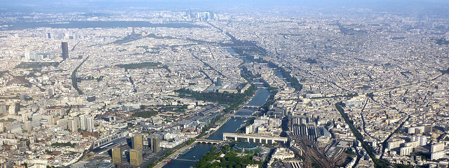
The book is specifically concerned with tracing the emergence of the concept of social space—here, the physical space characterised as the forum within which social relations are constructed—within the wider history of French planning over the 20th century. Haffner shows how this concept of social space had its origins in the growing use of aerial photography to analyse the country’s urban development and to generate new perspectives and new propositions for the built form of this development.
As Haffner describes, the technique of using aerial photography in these ways itself began before World War I, and came to prominence during the war as a means of gathering military intelligence, with generals using photographs to gain a vue d’ensemble (“holistic view”) of the topography into which they had sent their troops to conduct trench warfare. They assembled expert teams of analysts composed of photographers, architects, engineers and even artists to collect and interpret images, and were known worldwide for their advances in these techniques.
Between the wars these techniques passed into the civil sphere. First into the analysis of colonial areas such as Indochina, where the geographer Pierre Gourou used aerial photographs to discern relationships between different patterns of human habitation and cultivation and different topographic forms visible across the Tonkin Delta. Then to France itself, where it was used to come to grips with the nature of Paris’ urban growth and to help mount an argument for new forms of suburban housing.
In the rebuilding that followed World War II, aerial photography became part of the mainstream of techniques used to analyse and plan the massive social housing projects with which France may now be associated. As a result, the way that aerial photography came to be viewed by social scientists in the country evolved hand-in-hand with how they viewed the project of modernity overall. And this is where Haffner starts to illustrate the irony she perceives in this history. The great value that aerial photography contributed to the social sciences and to social development efforts during that period was to provide a previously unseen, top-down vue d’ensemble specifically to inform and complement the analysis of social relations and social needs conducted on the ground. Aerial photographs could reveal the large-scale patterns and textures into which the city was woven. This gave rise to phrases such as “urban fabric” or “urban tissue”. Such phrases were originally metaphors borrowed from biological or organic perspectives of urban areas, but could soon be understood quite literally. They hinted at an ideological position undergirding many of the social scientists using these methods: that there was a previously little-seen organic relationship between society, built form, topography, nature. Where the urban fabric appeared from the air to embody harmonious relationships between social groups and between society and nature, the biological organism of the city was considered healthy. And where it did not, the layout of other, healthier areas could provide inspiration for its redevelopment.
Aerial photography thus hinted at both the diagnosis and the cure. But as the project of modernity began to be critiqued, so too did the meanings implied by the use of aerial photography, and the entire top-down perspective that it generated.
It is in this phase that the opposition between “top-down” and “bottom-up” perspectives began to emerge, especially through the work of urban philosophers such as Lefebvre. The “top-down”—originally the more novel of the two, now represented a state that had begun to overreach and misjudge the complexity of social relations and needs; the “bottom-up” was no longer the less novel perspective that social scientists had always had but the perspective of local individuals and communities that state planners (and aerial photography analysts amongst them) could not fully sense.
This is the irony that Haffner alludes to. The “top-down” perspective of aerial photography originally gave social scientists a new perspective on social relations and needs, indeed gave rise to the idea of social space itself, but was ultimately rebuked for being blind to that social space and insensitive to those same relations and needs, which it was first to illustrate.
The historical account that Haffner produces is in many ways very subtle. Rather than really drive home on a single focus—whether social space, aerial photography, or urban planning—Haffner weaves back and forth between them. On the one hand it is the kind of account that inspires new ways of thinking about how we have used and how we could use aerial photography and other mapping techniques in the past and in the future. On the other it makes it very difficult for the reader to judge to what extent aerial photography is an instrumental variable in this story, a hitherto unacknowledged underlying force in history, or merely an interesting angle on the history of French planning and the concept of social space. But either way it allows us to reconsider the antagonism between “top-down” and “bottom-up” planning perspectives, and appreciate how the two provide different kinds of knowledge, and be used as complementary rather than mutually exclusive planning approaches.
Haffner’s account makes one think of a further irony, which is that despite (or perhaps because of) the ubiquity of aerial photography now, through products such as Google Maps, the proponents of the “top-down” perspective—the state, the large planning agencies, etc.—do not make use of aerial photography in anything like the rather beautiful and organic phenomenological approach taken by early geographers such as Gourou in the Tonkin Delta, searching for harmony between social relations, built form and natural landscape. The View from Above suggests that these more promising techniques are fading from our sights, but have not yet been forgotten completely.
Please read our comments policy before commenting.
Note: This article gives the views of the authors, and not the position of USApp– American Politics and Policy, nor of the London School of Economics.
Shortened URL for this post: http://bit.ly/Hz3IeA
—————————————–
Kerwin Datu – LSE Geography and Environment
Kerwin Datu originally trained in architecture, in which he worked in Sydney, Paris and London, before completing the MSc in Urbanisation and Development at LSE. He is now pursuing a PhD on the role of the global city network in international economic development, focused on African cities. As Editor-in-chief of The Global Urbanist, he receives and publishes essays and magazine articles on issues affecting urban development in cities around the world, and is always open to submissions from new contributors. Read reviews by Kerwin.