by Alexandra Gomes, Apostolos Kyriazis, Clémence Montagne & Peter Schwinger
Supported by the LSE Middle East Centre, LSE Academic Collaboration with Arab Universities Programme, LSE Cities and the Department of Architecture and Design of Abu Dhabi University have joined forces at an attempt to interpret Abu Dhabi’s urban development and improve our understanding of the role of road infrastructure in forging socio-spatial conditions.
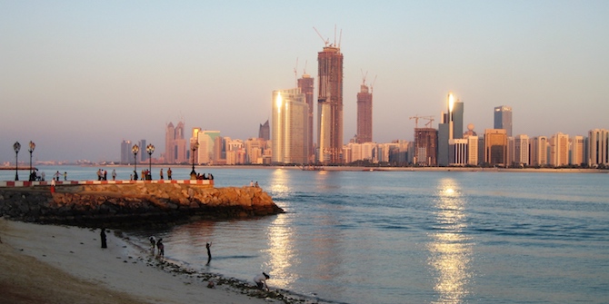
Abu Dhabi’s existing agglomeration of 1.8 million inhabitants (2016) has a mere 50-year history. The birth of the modern United Arab Emirates (UAE) capital was accompanied by the eradication of the pre-oil settlement. The city of today is largely shaped by modernist urban planning, in which the street dominates an urban field of an extreme zoning system. The early master plans of Harris, Halcrow and Arabicon (1962) kick-started the transformation, while Takahashi (1968) offered modernist glimpses for the development of the new downtown. It was Abdelrahman Makhlouf though, that both generalised the grid throughout the island and organised it by introducing his neighbourhood modules. Highly inspired by the work of Konstantinos Doxiadis in the region, Makhlouf delivered a plan that ‘(…) reflects [local] traditions. You don’t have to walk far to visit your family, and you had all your services, including the mosque and school, nearby’.
A short documentary reflecting some of these changes on YouTube.
This balance between the automobile and pedestrians was thrown off after two major construction booms in the 1980s and a post-modernist architectural turn (with an emphasis on the use of aesthetics for ‘social status’ purposes). Further variants of neoliberal urbanisms have been added since 2004. It was the pace of the transition, though, that led to the full conversion of the ‘street’ into a ‘road’ and to automobile dependency – a ‘car culture’ that oddly addressed local climatic and cultural particularities and is now fully embedded in all aspects of daily city life.
This car culture has had its visible impacts. Since 2000, the city expansion has surpassed its population and density growth, all supported by the fast growing road network where 4 lane dual carriageways predominate (and represented 50% of all external roads in 2019). For a city of less than 2 million inhabitants, its urban living area (a proxy for urban footprint) has expanded by a massive 252% since 2000, with a subsequent impact on the extended road network connecting this development. Consequently, Abu Dhabi has been very well placed on the urban mobility readiness index rank, due to its advanced road system in terms of quality, connectivity and the ability to support traffic movement. However, its car-centric development has led to low levels of walkability and high levels of traffic accidents and road deaths, even in a city considered extremely safe.
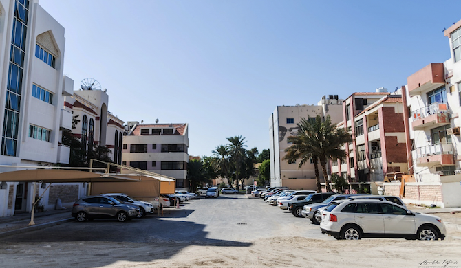
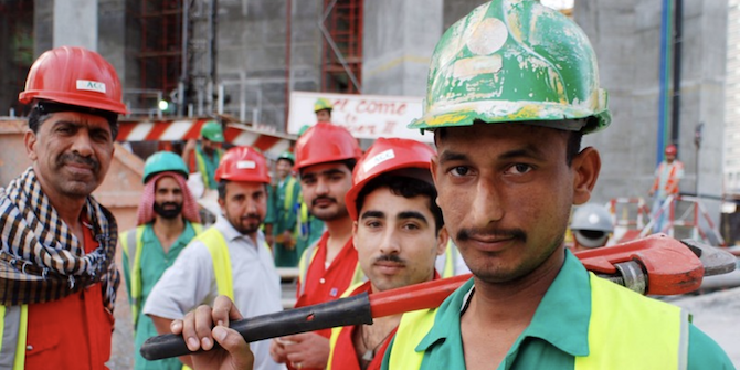
With dominant lower densities, low levels of mixed use (with only 31% of residents living near services), low block density (52 per km2 when the walkability goal is 80 per km2), and parking spaces dominating the street space (only 22% of car free spaces in the city), walkability at the neighbourhood scale is clearly impacted by entrenched highways or double-lane high roads, the only road design imagined by most road engineers and transportation planners. However, despite the automobile dominance, a significant part of the population does not own a car, and 23% walk or use other active modes of travel. This includes those living in labour camps and other low income workers (which represent 84% of the population in 2016). For those who walk, trips are kept to a minimum as walking infrastructure is lacking. In Abu Dhabi there is no adequate transport infrastructure. Finally, the city also lacks green spaces and the existing ones are not close to residential zones and have poor facilities. All this helps to explain the city’s high levels of CO2 per capita and its third place on a ranking of 500 world cities by the size of their carbon footprint.
The urban form, open space and car dependency still form a vicious circle that is too solid to break. It is embedded in a social and spatial practice of not only urban life but also urban development procedures, from decision- and policy-makers to consultants drafting the future planning of mushrooming neighbourhoods. While the urban form has already been scrutinised by scholars, and many of these indicators have been widely discussed, a lot of questions still remain: are the roads that connect different parts of the city also barriers that divide them? How has the road network affected city functionality? What is its impact at the socio-economic and cultural levels and how is that expressed in different scales of reference?
Remarkably, this radical transition from the local street (in the old town) to the sprawling roadscape in modern Abu Dhabi occurred within a lifespan. Therefore, its impact can be documented and analysed using a wider array of methods that also include ethnographic studies and interviews. In a city that is changing too quickly to learn from its own mistakes, people – as carriers of its collective memory – may shed light on uncharted properties and neglected parameters. This is all the more relevant in a city where a large proportion of its inhabitants, in particular the expat community, is renewed every 3 to 5 years. This project aims at performing its inquiry in two scales of reference: the metropolitan and the neighbourhood level. If roads and cars have an intrinsic presence at the city level, at the neighbourhood level the human element appears stronger and the streetscape acquires specific qualities. The choice criteria for the case study areas will hinge on the existence of specific and distinct characteristics of urban morphology, street network layout, socio-ethnic composition and other notable street-related features.
In addition to that, comparability and reference to similar cases in other cities in the Persian Gulf will be two more criteria to consider. Since Abu Dhabi is founded on a ‘tabula rasa’ context and continues to grow under an over-regulating framework (where an over-detailed and stringent set of standards and regulations prevent any design or programme flexibility), similar observations and references could apply to many other cities in the region (and beyond). Alexandra Gomes and Apostolos Kyriazis together with Clémence Montagne and Peter Schwinger will use their knowledge, both scholarly and quotidian, of the city and add their vantage point on issues that have global significance. The research team will work on a two-year research project, Roads as Tools for (Dis)connecting Cities and Neighbourhoods, that will use an entire city as a dynamic urban lab.