Understand India – One State at a time

The South Asia Centre is proud to launch a free, interactive online portal that compiles political, economic, social, demographic, policy and geographic data on India.
Using data from the Census of India, Election Commission of India, charities, think tanks and various government departments, it visualises key data sets of over 1.3 billion people across India.
![]()
The States of South Asia is being launched with a pilot of India before it expands to cover all countries in South Asia.

This map uses an award-winning LSE platform to display key political data for anyone wanting to understand Indian politics, and includes information on the Vidhan Sabha, Lok Sabha and Vidhan Parishad data of each State and Union Territory.
A window into LSE research
The map is also a unique resource that allows users to easily access hundreds of research articles, opinion and analysis on India from the London School of Economics.
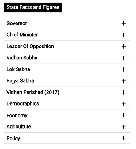 Explore key State Facts and Figures
Along with key sets of political information, this map has a wealth of demographic, economic, agricultural and policy data.
Use the ‘State Facts and Figures’ section to understand, analyse, compare and contrast Indian States and Union Territories.
Discover ‘The States of South Asia‘ Now
————————————————————————————————————————————————-
Disclaimer
This version of ‘The States of South Asia’ is a pilot. The boundaries of India conform to the official boundary as outlined by the Ordnance Survey of India with the exception of Lakshadweep Islands which is not represented due to a last-minute technical failure. The site contains information and data compiled by LSE South Asia Centre. While the information presented here has been compiled very carefully and is deemed accurate at the time of publication, the LSE South Asia Centre does not claim that it is free from error or omission. Users should note that the contemporary relevance of the portal means that the accuracy of information provided here will change constantly. The data and information on the site is made available with the understanding that it will be reviewed and amended after a 3-month period following an internal review in August 2019; the inaccuracy in the map of India will be updated sooner, if possible.


Undoubtedly a treasure for researchers and activists.