Charles Booth’s London Poverty Maps. London School of Economics and Mary S. Morgan, Inderbir Bhullar, Sarah Wise, Anne Power, Katie Garner, Aileen Reid and Jacob F. Field, with a foreword by Iain Sinclair. Thames and Hudson. 2019.
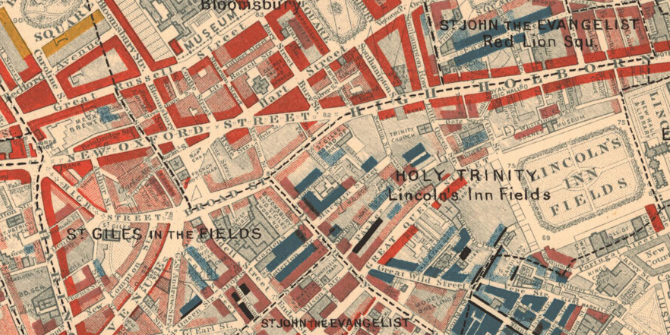
“I may here draw your attention to the many coloured map hanging on the screen, which I have called the Map of East End Poverty. Although it is on a large scale – 25 inches to the mile it requires a near view, and even needs a magnifier to be seen properly. It has been tinted with various shades of colour – from pink, through violet and blue, to black – to represent the condition of the people.” (Charles Booth, 1888, 284-85)
Charles Booth first presented his poverty mapping project to an audience at the Royal Statistical Society over 130 years ago. His monumental study, which resulted in seventeen volumes of written analysis, hundreds of handwritten notebooks – and most vitally, a masterwork of two series of maps that created a detailed chromatic coding of London’s patterns of life and labour in the last two decades of the nineteenth century – continues to be fascinating both in its providing visual records of the past, as well as social scientific evidence of ongoing relevance.
Charles Booth’s London Poverty Maps have been issued in a sumptuously illustrated, large format (36.5 x 26.5 cm) book by Thames and Hudson in conjunction with the London School of Economics and Political Science (LSE). LSE Library is home to the Booth archive whose importance is recognised by its inscription on UNESCO’s UK Memory of the World Register. While there have been dozens of publications relating to Booth’s project throughout the past century, this latest publication is probably the most comprehensive printed pictorial record of it to date.
The book’s opening pages explain how Booth started his inquiry into the life and labour of the people of London in the 1880s, having gathered together a self-funded team of researchers to capture data on the true nature and extent of poverty in London, with the aim, Booth wrote, of showing ‘the numerical relation which poverty, misery, and depravity bear to regular earnings and comparative comfort, and to describe the general conditions under which each class lives’ (Charles Booth, 1889-97, 6.).
The book provides an essential guide to the landscape of poverty in late-nineteenth-century London, much of which can be gleaned from the ‘morbid beauty’ of the descriptive maps, as Iain Sinclair’s ‘Forward’ to the book puts it. The two series of map surveys (of 1889 and 1898-99), their extents as well as the systematic methods used for the study, are explained through excellent graphic presentations throughout the book, while the book’s five thematic chapters (on housing, immigration, religion, trade and morality) reflect the principal themes of the inquiry. The thematic chapters are interspersed with interleaving sections for each of the twelve districts. Each section contains the full extents of the maps alongside detailed descriptive statistics, photographs and other pictorial sources. The reproductions of sample descriptions from Booth’s notebooks bring the data to life with visceral language that records the experience of walking the streets of London, while photographs of people such as a cat’s meat man enrich the scholarly accounts.
Mary Morgan’s ‘Introduction’ highlights the importance of Booth’s work as a social scientist. Rather than relying on a single source of data, she writes, Booth triangulated data on individual household surveys, observations regarding patterns of work statistics as well as qualitative findings from researchers spending time in the studied areas – either by staying with families, or by spending time in workshops – in order to get a multidimensional insight into life and labour, and not, as she points out, just poverty.
In fact, various contributing authors highlight the fact that this project was not so much a static snapshot of income levels, but a study of social conditions, yet there is an interesting debate played out on the book’s pages over whether this was an entirely objective study. Morgan argues that despite the apparent moralistic language of the class categories (with ‘vicious, semi-criminal’ for the bottom class being the most extreme example), Booth’s research showed that the principal causes of poverty were not just income levels, but particular circumstances, such as irregularity of income or accidents, ill health and old age. In contrast, Sarah Wise argues in her chapter on ‘Morality’ that Booth’s team was ‘relentless’ in its negative judgement of supposedly feckless behaviour.
The book also highlights various important themes relating to the relationship between poverty and housing, urban design or planning. In fact, the maps’ importance as evidence for the spatial dimensions of social cartography (as I have termed it) is highlighted by Morgan, who ends her chapter by observing how the survey’s cartographic records ‘introduced a way of saying a city is mapped in socio-economic space’ (41). The maps don’t just illustrate issues of displacement caused by urban change, but also the domino effects of improvement, having both social and spatial influence on adjacent areas. So, for example, we can see the impact of the main railway stations and tracks in acting ‘like tourniquets’ (see the classic 1967 paper by H. J. Dyos on the slums of Victorian London) to restrict the lifeblood of areas where Londoners were just getting by: in places improving inner city slums by replacing them with model dwellings, but for the poor, as Anne Power shows in her chapter on ‘Housing’, displacing poverty to ‘ever tighter spaces’ (80). The latter chapter abounds with examples of the spatiality of poverty, such as in descriptions of how streets of deep poverty, coloured black in Notting Dale, housed the ‘casual poor’, who were working for the rich of Kensington living in nearby streets, coloured red or gold.
The book also provides an important analysis of how London’s rapid growth in the nineteenth century shaped patterns of poverty and wealth across the Victorian metropolis that are persistent to this day. The chapter on ‘Religion’ by Aileen Reid is especially insightful on the social and economic aspects of religion such as churchgoing habits, the impact of clergy’s outreach work and the economic consequences of charitable giving, with some interesting observations on Booth’s team’s attitude towards the recently arrived refugee Jews living in the East End. She comments on the map drawn up in 1899 by George Arkell (one of Booth’s team) of Jewish East London, which uses a visual language borrowed from the poverty maps, with the cold, dark colours used to denote poverty on the Booth maps used here to colour the Jewish majority streets, and the warm tones of Booth’s prosperity correspondingly used to denote predominantly non-Jewish streets. Inderbir Bhullar’s closing chapter on ‘Leisure’ provides a necessary counterweight to the focus on poverty, by highlighting, through some striking descriptions of music halls and clubs, how important leisure was for the poor in providing them with ‘escapism, excitement or companionship’ (283).
And so to the legacy of Booth’s work. We learn that by the turn of the century Booth’s analysis had not only overturned many of the prejudices regarding the nature of deprivation in London, highlighting the complexity of ‘situation’, but also had practical outcomes, such as legislation to record overcrowding in the census and a successful campaign for an old age pension. His methods were replicated in subsequent social studies, most notably in the 1895 Hull-House study of Chicago that drew up an even more detailed set of coloured maps of nationalities and of wages. But Booth’s legacy is longer still. It is reasonable to state that his social scientific methods helped establish the academic discipline of social science. While we continue to battle with social issues that were already being tackled 100 years ago, it is worth revisiting what we learned at the time: how poor housing areas can diminish the circumstances of local communities, while poor housing management or upkeep can have a significant impact on people’s lives.
You may also like this interview with Indy Bhullar, who is a curator at LSE Library and part of the team behind the book.
♣♣♣
Notes:
- The 12 sheets of the 1898-99 survey can be downloaded free from the LSE website, while readers can compare London’s streets today with how they were in Booth’s time here.
- This blog post appeared first on LSE Review of Books.
- The post gives the views of its author(s), not the position of LSE Business Review or the London School of Economics.
- Featured image: map descriptive of London Poverty 1898-1899. Sheet 6. West Central District
covering Westminster, Soho, Holborn, Covent Garden, Bloomsbury, St Pancras, Clerkenwell, Finsbury, Hoxton and Haggerston. LSE reference no. BOOTH/E/1/6 (no known copyright restrictions). - Before commenting, please read our Comment Policy
Laura Vaughan is professor of urban form and society, and director of the Space Syntax Laboratory at the Bartlett School of Architecture, UCL. She has led a number of interdisciplinary research projects that consider some of the most critical aspects of cities today, ranging from ethnic segregation and health, poverty and housing, to economic and social vitality. Her book, Mapping Society: The Spatial Dimensions of Social Cartography, was published open access with UCL Press in 2018. Read more about her work on her blog and Twitter: @urban_formation