by Monica Castañeda, Ricardo Fernandez & Roberto Robles-Arana

The implementation of a new Bus Rapid Transit (BRT) line, Mi Macro Periférico, in a 12-lane peripheral ring known as Periférico in Guadalajara, the third-largest metropolitan area in Mexico, became the opportunity to reshape one of the main roads of the city. Periférico was established during Guadalajara’s urbanisation, between the 1960s and 1970s. The economic and social development of the city resulted in population growth and in turn, an increase in neighbourhood settlements outside the historic centres. However, by the 1990s, the excessive and disorderly growth of the city absorbed Periférico, rendering it just another connector in the broader metropolitan street network. This development undermined Periférico’s perimetric character, and instead created a new division between central and peripheral neighbourhoods. It was during these years too, that public transport played a significant role in facilitating mobility and interconnectivity between different parts of the city. However, the latter’s services have been inefficient and overburdened.
As a result of the urban development model Guadalajara followed, today the city outskirts are higher density areas, while the historical, economic, commercial and administrative heart of the city is very depopulated. Such conditions establish a dynamic of mobility whereby a significant flow of people travel from periphery to centre every day.
On this note, Periférico runs along four different municipalities of the Metropolitan Area of Guadalajara. It connects some of the most important parts of the city: the educational, cultural, athletic, religious, commercial and industrial spaces. More than half a million inhabitants live in these neighbourhoods with a mean density of 84 inhabitants per hectare, some of which even have densities as low as 1. Even if some of the neighbourhoods are residential, there are numerous industrial (15% of the land use) or commercial zones (23%) and greenfields (23%), where the urban morphology involves large and inactive urban blocks that shape pedestrian traffic.
Nowadays, crossing Periférico as a pedestrian is not an easy quest, mainly due to the few crossing opportunities that exist. It was in this context that Mi Macro Periférico was developed as the new BRT line. It was an opportunity to redesign Periférico and weave the centre and periphery together. The entire project was conceptualised as an integral intervention; the new system is 41.5 km long and composed of 42 stations. Yet, how can we increase permeability between the peripheral and central parts of Guadalajara, especially at the pedestrian scale?

In effect, the design of the new BRT includes the construction of 40 new pedestrian bridges, which combined with the existing 57 helped increase permeability between the centre and periphery. While pedestrian bridges are not the optimal solution to solve a pedestrian crossing, due to Periférico’s context they can have a positive impact on permeability – as long as they are well located.
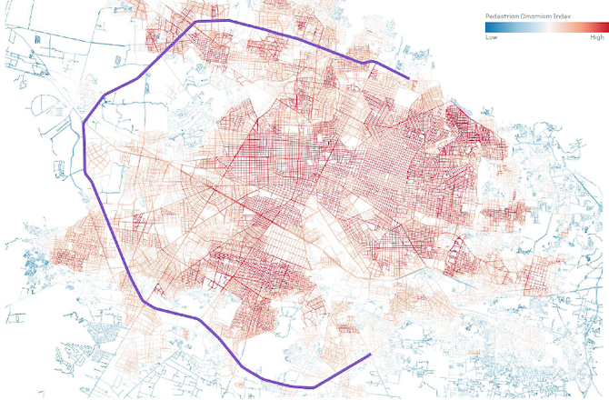
Therefore, a decision-making methodology named the Pedestrian Dynamism Index (PDI) was developed based on Space Syntax analysis, population density and local economic figures. Its aim is to decide on the particular location of pedestrian bridges and access to BRT stations. This methodology was born out of a need to have a graphic tool that would allow individuals to visualise and measure the potential each street has to accommodate pedestrian trips, especially around Mi Macro Periférico’s stations. Moreover, the methodology acknowledges that the urban experience is shaped by socioeconomic characteristics that need to be taken into account during the design process.
To build the index we followed three steps. First, we had to unify geometries since the information we were working with had different shapes. This meant converting local economic data given in points into lines and demographic data contained in polygons into lines as well. Integration and choice, the measures obtained from the Space Syntax analysis were already represented as lines. At that moment, we had four attributes with the same geometry but at different scales and ranges. The second step was standardising the values using standard deviation. Once the values were normalised, we could perform simple arithmetic calculations. To finish the index, we added all variables and got the Pedestrian Dynamism Index.
The result is demonstrated on the following map, where warm colours represent the shortest streets with the most connected paths to the system. These have a high concentration of economic activity and more people tend to live there. As a result, the pedestrian bridges and access points to the stations were placed close to these streets. Doing this is expected to increase the permeability between the centre and the periphery, as well as to ensure the most direct and dynamic routes towards the stations.
In addition to the use of the Index for the Mi Macro Periférico project, it was used for Colomos III, a site belonging to one of the most important green reservoirs of the city, but closed to the public. The site sits between two different neighbourhoods; on the right is one of the most exclusive residential, gated communities while on the left is a middle to working class residential area notable for its very dynamic commercial life. As a result of the analysis, the PDI demonstrated the potential the park had to improve connectivity between the two neighbourhoods through internal pathways.
In conclusion, the tool has proven to be extremely powerful for decision-makers since it provides them with clarity during the design process. It can also serve as a tool during the planning process by identifying the corridors that have the potential to allocate pedestrian trips towards a transit station. Moreover, we are working on a Cyclist Dynamism Index to expand the cycling infrastructure network of the city. The Pedestrian Dynamism Index represents an effort to improve the urban experience through a data-driven decision-making process.

This piece is part of a series on urban development and the role of road infrastructure in forging socio-spatial conditions, based on contributions from participants in a closed LSE Roundtable in September 2021. Read the introduction here, and see other pieces below.
In this series:
- (Re)thinking Streets in Low Urban Densities by Alexandra Gomes, Apostolos Kyriazis, Clémence Montagne & Peter Schwinger
- The Future Development of the City of Kuwait: Kuwait’s Urban Form as a Case Study by Roberto Fabbri
- Pedestrian Dynamism Index: An Approach to Increasing Permeability between the Peripheral and Central City of Guadalajara by Monica Castañeda, Ricardo Fernandez and Roberto Robles-Arana
- Studying Abroad in Stockholm: Incentivising Young Adults Towards Greener Mobility by Ningning Xie
- Plan with a Purpose: A Systems Approach in Transportation Development and Liveable Cities by Lizao Chen
- Metropolisation and Spatial Segregation in Gulf Cities: The Cases of Abu Dhabi and Dubai by Moiz Uddin
- Rethinking Streets in North Obhur, Jeddah, Kingdom of Saudi Arabia by Alok Tiwari
- Safe and Active Mobility: A Prototype for the Re-Pedestrianisation of Residential Neighbourhoods in Oman by Gustavo de Siqueira
- Urbanisation and Physical Activity: Addressing the Needs of Omani Women by Ruth Mabry and Huda Al Siyabi