by Dhari Alrasheed & Nuno F. da Cruz

The most significant critical juncture in the shared history of Arab Gulf countries was the discovery of oil in the first half of the last century, which prompted major economic transformations. The political systems and demographic features of these states, however, exhibit subtle but important differences. This meant that different models of harnessing and deploying the newfound wealth were followed, with different priorities and strategies to growing their economies, developing their cities, and improving the lives of their inhabitants.
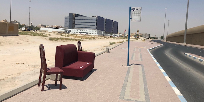
Despite having the longest running elections for a Municipal Council and the oldest directly elected and politically powerful National Assembly among its Gulf peers, Kuwait suffers from urban problems that are all too familiar across the region: low-density sprawl, heavy reliance on cars, limited use of public space and, above all, the unmistakable spatial segregation between Kuwaitis and non-Kuwaiti migrants (who constitute 68% of the 4.46 million population). The latter is particularly concerning because it has been empirically linked in other contexts to various negative socioeconomic outcomes such as the formation of ghettos and ethnic enclaves, negative neighbourhood peer effects (e.g., mimicking criminal behaviour), spatial mismatch between work and residence, unequal access to public goods, and decline in social capital.
But just how serious is spatial segregation in Kuwait? And what may be causing it? We sought to answer these questions through our investigation on the ground, and one of the main working hypotheses was that urban governance arrangements may be an important part of the story.
How Spatially Segregated is Kuwait?
To quantify spatial segregation, we employed several indices that capture the multi-dimensional nature of the phenomenon using data at the district and block levels. The results indicate that, while Kuwait was already highly segregated in 2000, it has become even more so since then. Using data for 2020, we found that 79% of non-Kuwaitis would have to relocate across neighbourhoods for the two groups to be distributed evenly. Spatial isolation is also high, with the average non-Kuwaiti residing in blocks where 84% of residents are also non-Kuwaiti. Other indices related to spatial concentration, centralisation, and clustering provide further evidence of a highly divided society. Overall, the high segregation scores are consistent with the formation of ghettos found in other settings. We also find substantial spatial variation in these results, with higher segregation scores found in governorates with the largest shares of the non-Kuwaiti population (Farwaniya, Hawally, and Ahmadi).
Segregation may be attributed to people’s uncoordinated self-sorting, based on socioeconomic status or unobserved preferences and attitudes. Alternatively (or additionally), given Kuwait’s history of exclusionary housing and land use policies that still apply to the present day, it is likely that the observed segregation is partly a result of top-down, centralised planning, or of collective action by the politically dominant group (Kuwaitis) through their elected legislative bodies. For example, the various masterplans have explicitly designated residential areas for Kuwaitis and non-Kuwaitis, zoned as single- and multi-family housing, respectively. Furthermore, home ownership is reserved for Kuwaitis only and single-family housing rental is either illegal or unaffordable for most non-Kuwaitis. Establishing causal links for any of these hypotheses is not possible due to data limitations, but our analysis points to strong associations between land use policies and segregation.
Whatever the root causes – and despite the wealth of evidence and practical guidance for more sustainable modes of urban development – Kuwait’s model of urbanisation is clearly riddled with negative and unsustainable environmental, social, and economic outcomes. What is, then, preventing decision-makers from adopting alternative models? Our sense is that this policy inertia may be linked to how urban governance works in Kuwait.
Networked Urban Governance
To explore urban governance arrangements, we set out to identify the key actors involved in strategic spatial planning in Kuwait. But determining who these actors are is not enough. To assess their relative ability to influence strategic decisions, we also analysed the social structures arising from the way these actors are interconnected. We conducted structured interviews with representatives of a diverse range of organisations with stakes in the spatial development of Kuwait. In their answers, these representatives referred to other individuals and organisations involved in or impacting their work. This process eventually led to a network of 153 different actors.
Figure 1: Kuwait’s Strategic Planning & Spatial Development Governance Network
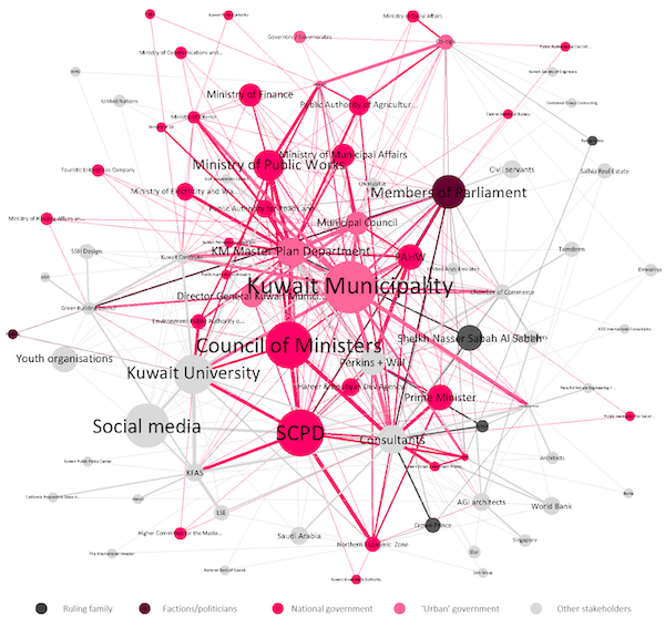
We then performed a social network analysis which revealed that the governance of strategic planning and spatial development in Kuwait is dominated by municipal and national government actors, due to their position in the network. Unsurprisingly, given our emphasis, Kuwait Municipality and the Supreme Council for Planning and Development top many of the rankings of centrality. However, the Council of Ministers’ position indicates that significant decision-making power is placed on an executive body that lacks an urban focus. With very few exceptions – most notably Kuwait University and some consultants – non-government actors are pushed to the network periphery. This includes other subnational entities, civil society, and the private sector (e.g., developers and construction companies). Overall, spatial planning in Kuwait is highly centralised, though fragmented across several government entities, to the detriment of a governance approach where decisions are made closer to the people they affect.
The network also exhibits a high degree of homogeneity, whereby the expertise of the most central actors is either purely technical or, at best, cross-cutting, with almost no socially-oriented actors. As one respondent put it, urban governance in Kuwait lacks “people that think about the urban in an integrated manner, not just about buildings”. As it stands, social issues, environmental concerns, and other domains that are critical for sustainable development are likely to be overlooked. The analysis suggests an exaggerated focus on land use that is detached from social policy and concerns with transport or mobility. It is hardly surprising, therefore, that issues of spatial segregation, traffic congestion, and unequal access to services, amenities, and economic opportunities have arisen in Kuwait.
Where Can Kuwait Go from Here?
Our findings do not allow us to establish with certainty whether spatial segregation in Kuwait is born out of technocratic, politico-ideological, or social dynamics. However, the evidence suggest it would be unwise to dismiss any of these domains, and that changing this situation will require reforms across all of them. So, what can policy-makers do?
First, social and environmental concerns can be elevated by diversifying the urban governance network in terms of stakeholder type, their expertise, and the concerns they represent. Second, a culture of collaboration, not competition, among government actors should be promoted to make the policy-making process more efficient and improve the quality of its outcomes. Third, powers could be decentralised, either to existing entities (like co-ops) or to new elected local bodies. And fourth, housing and land use policies need to become more inclusive and oriented towards improving the liveability and accessibility of all neighbourhoods. These interventions would be to the benefit of the whole society—both Kuwaitis and non-Kuwaitis
This blog post is part of the Kuwait Programme research project ‘Governance of Spatial Change: Shaping Urban Policies and Investments in Kuwait’ Nuno F. da Cruz and Dhari Alrasheed are the principal investigators on this project.
[To read more on this and everything Middle East, the LSE Middle East Centre Library is now open for browsing and borrowing for LSE students and staff. For more information, please visit the MEC Library page.]