Increased flooding is just one of the impacts of climate change that we are currently facing. In this project we are looking at flood adaptation in Dar es Salaam and London, more specifically the flood adaptation taking place in relation to the River Ravensbourne in Lewisham and the rivers Msimbazi and Kibangu which surround the Kigogo settlement.
Dar es Salaam and London: Structure and Actors
In London, there are several actors involved in flood adaptation. Private drains or sewers are the responsibility of private landowners or their landlords, while flooding from drains or gullies is the responsibility of the local council. The Borough councils are responsible for providing accommodations to people post-flood. The Borough of Lewisham council asks residents to report to the National Environment agency in the case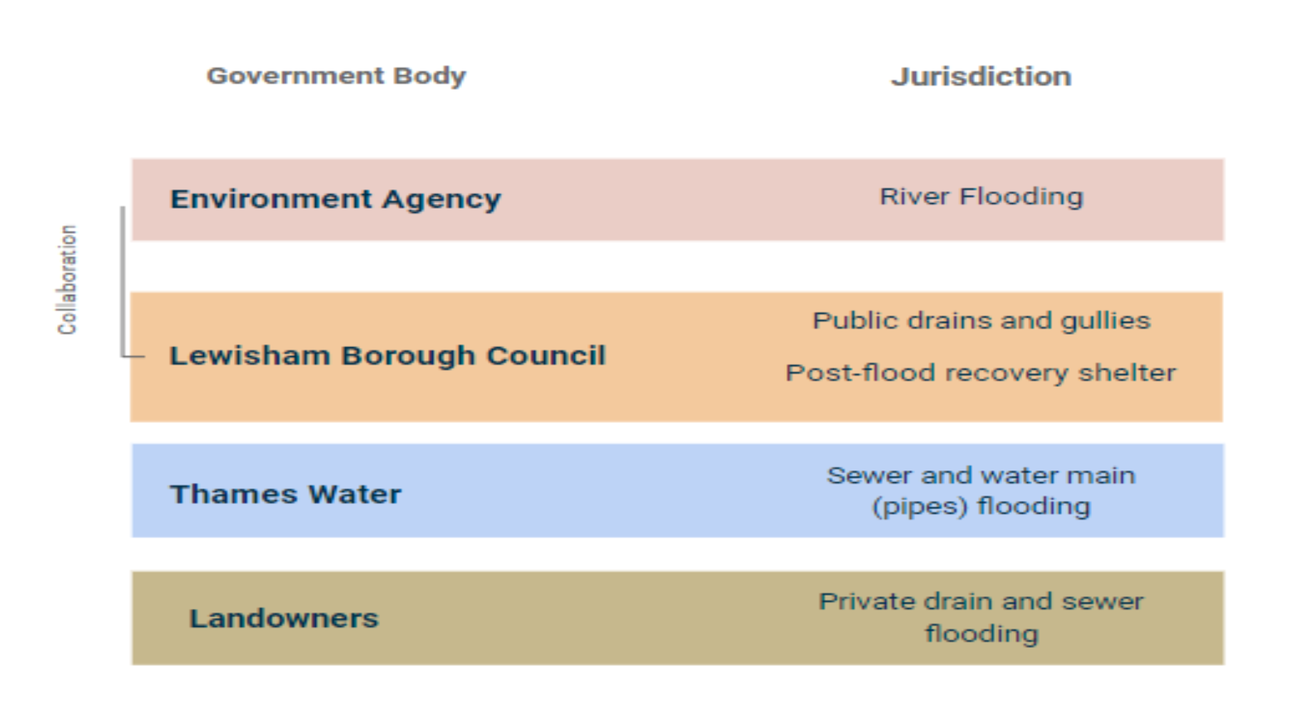 of flooding from rivers, as well as the NGO National Flood Forum, a charity helping provide advice to people recovering from flood impacts. Furthermore, Thames Water is responsible for any flooding caused by public sewers or burst water mains.
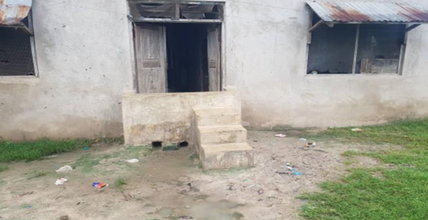
In Dar es Salaam, initiatives have been taken at the individual level, local level, and national dimensions. These have been taken by three main actors, the government, the oil companies, and Red Cross Tanzania. Oil companies provide oil to operate an excavator. Red Cross Tanzania facilitates the planting of trees which act as a buffer zone as well as neutralise the soil to prevent the flooding water from reaching their settlement areas. There is also lots of action at an individual level, such as individuals making their own flood risk apparatus for their own homes. For example, the barrier constructed with steps leading into a home pictured below.
Flood Mitigation and Prevention in Lewisham and Dar es Salaam
As both areas are prone to flooding, they have developed their own responses to flood mitigation. These include both prospective and corrective measures. Prospective measure are used “to keep people and properties away from flooding” and include urban planning, land use policies, and building codes, while corrective measures are used “to reduce flood risk of properties that are already at-risk areas”, including flood defence, property flood protection measures, and establishment of natural barriers (Week 4 Lecture).
Kigogo, Dar es Salaam
Regarding its prospective measures, Dar es Salaam is lacking a formal government response to urban planning and preventative measures to reduce flooding damage. Where the local and national governments are lacking, community-based initiatives are filling such gaps. The creation of the Ramani Huria mapping system is helping to provide highly accurate maps of the most flood-prone areas of the city. This mapping system is funded by the UK Department for International Development through the Tanzanian Urban Resilience Programme and not only provides a tool to bring informal and unplanned settlements onto a map but also brings awareness of the need for flood prevention and risk reduction in the city.
Dar es Salaam’s corrective measures are also highly influenced by community initiative and action. Since many of its settlements are unplanned and informal, there is no structured urban planning measures in force to reduce flood-related damage. Instead, communities such as Kigogo take matters into their own hands to prevent increased damage. These measures include local efforts to clean and widen the river, as well as building river barriers (the national government and some oil companies provide limited aid by bringing in an excavator once a year to help these efforts). At the individual level, citizens construct concrete barriers around their houses to prevent floods from reaching the house, or construct their houses on a higher level to reduce the damage to the interior of the house. Finally, NGOs such as Red Cross Tanzania helps plant trees such as bamboo and coconut trees to create a buffer zone between the river and these settlements.
Lewisham, London
Comparatively, Lewisham’s flood response is largely addressed through its local council and city government. Its prospective measures include strict zoning and building codes that govern where development can occur within Lewisham and the necessary measures it must take to both prevent and mitigate flood-related damage. In terms of zoning codes, Lewisham has 3 levels of zones: Level 1 (low probability of flooding) has no restrictions on building and development, however, it must take into account the future potential of flooding; Level 2 (medium probability) prevents any emergency services from being constructed in that area and any development projects consider future impacts of climate change and flooding; Level 3 (high probability) dictates that development projects must undergo a “Sequential Test” and show proper techniques to minimise potential for flooding damage.
For its corrective measures, Lewisham has engaged in similar techniques to Dar es Salaam around physically altering the river, however it has gone even further in fully rerouting the river to avoid residential and commercial areas. Instead, the river now runs through the park centre, using the park as a natural barrier to flooding. This project first began in 2007 with a £400,000 project funded by the UK government and the EU, with a £2 million improvement project happening between 2009- 2010 which further modified the river to reduce flood-related impacts. Lewisham’s respective measures are mainly governed through its local council and governments, with most of its funding from national and international initiatives.
What can we learn?
We have found that London’s flood defence projects involve very top-down state-led infrastructure, whileinDaresSalaamweseeverybottom-up,communitydrivenaction. Neitheroftheseapproaches are better than the other but that they come about due to differences in political, economic, and spatial contexts. In Lewisham we could perhaps learn from the methods used in Kigogo, such as the self-provisioning, self-built flood infrastructure, and how resourceful these communities are despite their lack of funding and direction from the state.