
 After the fall of the Roman Empire, urban life in France became a shadow of its former self, but in Britain it completely disappeared. Guy Michaels and Ferdinand Rauch use these contrasting experiences as a natural experiment to explore the impact of history on economic geography – and what leads cities to get stuck in undesirable locations.
The world is rapidly urbanising, but some of its growing cities seem to be misplaced. Their locations are hampered by poor access to world markets, shortages of water or vulnerability to flooding, earthquakes, volcanoes and other natural disasters. This outcome – cities stuck in the wrong place – has potentially dire economic and social consequences.
When thinking about policy responses, it is worth looking at the past to see how historical events can leave cities trapped in locations that are far from ideal. We have done that in a study that compares the evolution of two initially similar urban networks following a historical calamity that wiped out one, while leaving the other largely intact.
 As Paul Krugman has kindly noted in a short piece on our research, we address one of the central themes of the ‘new economic geography’ that he pioneered: ‘the role of cumulative causation, and its tendency to lock in urban locations. Economic geography models stress the importance of various kinds of agglomeration economies, which give an advantage to firms or people who locate close to other firms or people. Such economies clearly lead to urban persistence: once there’s a clump of activity somewhere, it tends to stay there unless a big enough shock comes along.’
The setting for our analysis of urban persistence is northwestern Europe, where we trace the effects of the collapse of the Western Roman Empire more than 1,500 years ago through to the present day. Around the dawn of the first millennium, Rome conquered, and subsequently urbanised, areas including those that make up present day France and Britain (as far north as Hadrian’s Wall). Under the Romans, towns in the two places developed similarly in terms of their institutions, organisation and size.
But around the middle of the fourth century, their fates diverged. Roman Britain suffered invasions, usurpations and reprisals against its elite. Around 410CE, when Rome itself was first sacked, Roman Britain’s last remaining legions, which had maintained order and security, departed permanently. Consequently, Roman Britain’s political, social and economic order collapsed. Between 450CE and 600CE, its towns no longer functioned.
Although some Roman towns in France also suffered when the Western Roman Empire fell, many of them survived and were taken over by Franks. So while the urban network in Britain effectively ended with the fall of the Western Roman Empire, there was much more urban continuity in France.
The divergent paths of these two urban networks allow us to study the spatial consequences of the ‘resetting’ of an urban network, as towns across Western Europe re-emerged and grew during the Middle Ages. During the High Middle Ages, both Britain and France were again ruled by a common elite (Norman rather than Roman) and had access to similar production technologies. Both features help us to compare the effects of the collapse of the Roman Empire on the evolution of town locations.
Following the asymmetric calamity and subsequent re-emergence of towns in Britain and France, one of three scenarios can be imagined:
First, if locational fundamentals, such as coastlines, mountains and rivers, consistently favour a fixed set of places, then those locations would be home to both surviving and re-emerging towns. In this case, we would observe high persistence of locations from the Roman era onwards in both British and French urban networks.
Second, if locational fundamentals or their value change over time (for example, if coastal access becomes more important) and if these fundamentals affect productivity more than the concentration of human activity, then both urban networks would similarly shift towards locations with improved fundamentals. In this case, we would observe less persistence of locations in both British and French urban networks relative to the Roman era.
Third, if locational fundamentals or their value change, but these fundamentals affect productivity less than the concentration of human activity, then we should see ‘path-dependence’ in the location of towns. The British urban network, which was reset, would shift away from Roman-era locations towards places that are more suited to the changing economic conditions. But French towns would tend to remain in their original Roman locations.
Our empirical investigation finds support for the third scenario, where town locations are path-dependent. As Figure 1 shows, medieval towns in France were much more likely to be located near Roman towns than their British counterparts.
Figure 1: Roman towns in medieval towns in Britain and France
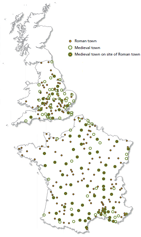
These differences in urban persistence are still visible today; for example, only three of the 20 largest cities in Britain are located near the site of Roman towns, compared with 16 in France. This finding suggests that the urban network in Britain shifted towards newly advantageous locations between the Roman and medieval eras, while towns in France remained in locations that may have become obsolete.
But did it really matter for future economic development that medieval French towns remained in Roman-era locations? To shed light on this question, we focus on a particular dimension of each town’s location: its accessibility to transport networks.
During Roman times, roads connected major towns, facilitating movements of the Roman army. But during the Middle Ages, technical improvements in water transport made coastal access more important. This technological change meant that having coastal access mattered more for medieval towns in Britain and France than for Roman ones.
We find that during the Middle Ages, towns in Britain were roughly two and a half times more likely to have coastal access – either directly or via a navigable river – than during the Roman era. In contrast, in France, there was little change in the urban network’s coastal access.
We also show that having coastal access did matter for towns’ subsequent population growth, which is a key indicator of their economic viability. Specifically, we find that towns with coastal access grew faster between 1200 and 1700, and for towns with poor coastal access, access to canals was associated with faster population growth. The investments in the costly building and maintenance of these canals provide further evidence of the value of access to water transport networks.
Our conclusion is that many French towns were stuck in the wrong places for centuries, since their locations were designed for the demands of Roman times and not those of the Middle Ages. They could not take full advantage of the improved transport technologies because they had poor coastal access.
Taken together, our findings show that urban networks may reconfigure around locational fundamentals that become more valuable over time. But this reconfiguration is not inevitable, and towns and cities may remain trapped in bad locations over many centuries and even millennia. This spatial misallocation of economic activity over hundreds of years has almost certainly induced considerable economic costs.
Our findings suggest lessons for today’s policy-makers. The conclusion that cities may be misplaced still matters as the world’s population becomes ever more concentrated in urban areas. For example, parts of Africa, including some of its cities, are hampered by poor access to world markets due to their landlocked position and poor land transport infrastructure. Our research suggests that path-dependence in city locations can still have significant costs.
This article summarises ‘Resetting the Urban Network: 117-2012’ by Guy Michaels and
Ferdinand Rauch, CEP Discussion Paper No. 1248 and originally appeared in the LSE’s Centrepiece magazine.
Note: This article gives the views of the author, and not the position of the British Politics and Policy blog, nor of the London School of Economics. Please read our comments policy before posting.
About the Authors
Guy Michaels is associate professor of economics at LSE and a research associate in CEP’s labour markets programme.
Ferdinand Rauch of Brasenose College and the economics department at the University of Oxford is a research associate in CEP’s globalisation programme.